

This text covers the study of a set of military structures preserved in what was a unique border area between Christians and Muslims in south-west Europe during the XIIth and XIIIth centuries. They are situated in a wide mountainous and wooded territory located in Segura de la Sierra valley, in the south-east of the Iberian peninsula, in Andalusia. This area formed the frontier for 280 years between the Christian kingdom of Castile, and the last territories of al-Andalus after the collapse of the Almohad military power, due to their defeat in 1212 in the Navas de Tolosa battle.
Due to the strategic position of Segura de la Sierra valley during the XIIth and XIIIth centuries, there were built several defensive fortresses both by Muslims and Christians. As a result, there are still remains of a well-preserved medieval tower system using rammed-earth technology that represents a magnificent heritage.
 |
The South Santa Catalina watchtower. Above the branches of the olive trees an entrance hole, blocked also in medieval times to reshape it into a loophole, can be seen. This tower preserves its original battlements practically intact.
|
The study and understanding of the main military structures of the Segura valley has been made from an exhaustive and rigorous stratigraphic and material analysis of the walls. It has enabled the understanding of its taxonomy and comparison with other similar examples inside and outside the Iberian Peninsula, allowing us to know and advance the knowledge of such common features as the constructional technologies, shape, typology, functional use and establishment in the territory.
The research we are doing has enable the discovery and demonstration of the arrangement of the access system to the watchtowers and illustrates it graphically. The historical significance and cultural references of these towers with their territory, the extended knowledge obtained of these early medieval rammed-earth architectures and the interest of the discoveries obtained due to the research made and the restoration project of some of them, are the main contributions of this paper.
During the Xth century a line of fortresses was built in al-Andalus in a short period of time, between the end of Abd al-Rahman III and the beginning of al-Hakam II reigns. So between a.d. 912 and 976. Amongst them were the castles of Tarifa, Gormaz, el Vacar and Burgalimar. The most advanced of these fortresses was Burgalimar that has an ovoid shape and consists of fifteen hollow towers with similar constructive features to those of the Segura valley. During the XIth and XIIth centuries, the constant Christian pressure across the frontier made urgent fortification works a priority. The almoravid carried out fortifications works in many cities of al-Andalus like Almeria, Córdoba, Seville.

After the break-up of the caliphate of Córdoba in one thousand thirty one the territory of Segura de la sierra was a cora or kurah in Arabian language. That was territorial district with own autonomy. Segura was the main settlement, and different farmhouses surround it, its name was alquerias. They were also walled enclosures linked to a tower that controlled the nearest cultivated areas. They fulfilled a dual productive and defensive function, and determined the economic and social development of this territory.
After the conquest and during the first Christian occupation in the years following the battle of Navas de Tolosa in 1212, Segura remained as the main town of a wide spatial area. The control over the headwaters of the rivers Guadalimar, Guadalquivir, Segura and the rich forest of these mountains, gave to this territory an important mercantile value, due to the fact that it was the gate towards Castile of the goods produced in the Islamic kingdoms of Granada and Murcia.

After the break-up of the caliphate of Córdoba in one thousand thirty one the territory of Segura de la sierra was a cora or kurah in Arabian language. That was territorial district with own autonomy. Segura was the main settlement, and different farmhouses surround it, its name was alquerias. They were also walled enclosures linked to a tower that controlled the nearest cultivated areas. They fulfilled a dual productive and defensive function, and determined the economic and social development of this territory.
 |
Borders between the Christian kingdoms of Castile and Aragon with the Islamic kingdoms of Murcia (Hudi dynasty) and Granada (Nasrid dynasty) between the 12th and 15th centuries. Distribution of the mountainous territory in the Sierra de Segura including four Commands (Encomiendas) of the Military Order of Santiago.
|
The gift of Segura town by the king of Castile to the military order of Santiago included not only the castles, towers and farms but other adjacent areas with the following productive units: lands, salt mines, vineyards, springs, rivers, mills, fisheries, meadows, pastures, holm oak and pine forest, tolls.
The close relation between the castles and the towns and the pairing of church-castle, as an essential part of the social Christian organization, is one of the linking elements of the landscape. This is combined with the rural situation, as the network of husun that did not develop into the cities. In the rural areas the husun consisted of fortified enclosures that were used as community refuges for the surrounding population in case of danger. In its interior was a watchtower and final defensive redoubt, which could be also used as store or cistern.

 |
|
Santa Catalina Plains with the situation of the three towers.
Above: View towards Segura de la Sierra town.
Below: View towards Puerta de Segura village, the entrance to this valley from the West.
|
This rural continuity was the result of the mudejar population remaining in the territory (mudejar were Muslims that lived in Christian region) The order of Santiago superimposed feudal structures of power and hierarchy on a spatial Islamic organization.
In addition to their productive function, this set of towers and wall enclosures would have formed part of the defensive line constructed between the twelfth and thirteenth centuries in the Levant corridor, this was a natural route dating back to prehistoric times that connects the Guadalquivir river with the east of the Iberian Peninsula. This set of walled enclosure, each with a tower, allowed for a rapid access from the alquerias spread in the valley to a safe haven, as the urban walls and the castle of Segura were too far away.
These fortresses were usually built on the higher parts of the slopes, controlling from a wing a flat cultivated area of between 250 and 350 hectares, with a relatively gentle topography that allowed for farming potentially irrigated lands. This is the most common settlement pattern in the area defined in the examples of Altamira, Gutamarta, la Torre, Cardete and Fuente de la Torre. These towers usually have a ground plan size of over 8 x 5 meters with the access relatively close to the ground as they are linked to a walled enclosure.

 |
|
Above: Segura de la Sierra valley with its mountainous and fluvial system.
Situation of the castles, towers, walled enclosures and watchtowers in relation to the topography,
the principal roads and agricultural areas controlled by the fortified enclosures of this valley.
Below: Views between the different towers and defensive enclosures of the Segura valley.
|
These small castles were strategically distributed in a triangulated fashion and favored the maximum protection of the closest agricultural lands. In this way the valley kept a lookout, enabling also a connection with other territorial external zones to control the troop movement over Segura valley and its surroundings.
Most of these towers belong to the husun type. Almost all of them are single stage constructions and have a truncated pyramidal shape, as in the examples of the twin towers of Santa Catalina. They are similar to the other structures but of slightly smaller size, they are watchtowers with the peculiarity that their access is at a considerable height from the ground, which leads to the conclusion that they did not have a fence nor formed part of a farmstead.
 |
| Tower and fortified enclosure of Cardete. |
The study of these fortresses permits the understanding of the building techniques used in these structures, allowing comparison with other contemporary examples in the Maghreb and the Iberian Peninsula. Almost all the Segura valley towers and walled enclosures have similar construction features using tabia (in Arabic terms) A building process that consisted of the construction of walls with tamped earth and lime using a refined technology that in Spanish was referred as tapia or tapial.
There is a generally held belief that this technology was spread in al-Andalus and the Maghreb by the Arabs, but rammed-earth wall were built previously in these place. Pliny in A.D. 79 recounted in the 35th book of his Natural History the existence of rammed-earth structures in Iberia and in Africa before the romans arrived. The material remains shows that the use of this technology in the Mediterranean basin goes back to at least the III century B.C. its origin can be traced to the near east civilizations and its diffusion in western Mediterranean has been attributed to the Phoenicians.
These types of rammed-earth constructions are generally modular, determined by the size of the timber formworks. They used to be between 2 to 3 meters long and 75 to 90 centimeters height, such as can be easily handled. This variation is considered to be determined by different local carpentry traditions during different periods of time. They also related to the metrology of Islamic construction systems, where the basic unit of measure was the cubit, deriving from the classical roman cubitus. The Islamic cubit was divided in two basic types: rasasi and maamuni. the first one was used mainly the emirate and the caliphate in al-Andalus. The submultiples of both types were the foot, the hand span, and the inch. the multiples were the yard (vara in Spanish) also referred to the medieval Spanish as caña, tapia or qala. a yard had two cubits and a cubit had six hand spans.
In al-Andalus, the measure unit or module referred to as a vara or yard was between 70 centimeters and 90 centimeters width, this measure in the defensive elements of the Segura valley is around 75 centimeters, being slightly different according to each tower.
The archeological interpretation of these shuttering elements contributes important and conclusive information on the construction of the rammed-earth walls. The retaining force of this shuttering was implemented by holding it in place with whole or half transversal timbers called agujas in Spanish. The half timbers did not cross the whole width of the walls. As a result, they remained inside the wall after the rammed-earth mixture was poured over them and tamped down. After removing the shuttering, the external part of these half horizontal timbers was cut off with an adze and their cut surfaces were covered with lime mortar.
On the other hand, the complete horizontal timbers were reusable. They were bigger and usually placed in the lower parts of the walls, because of the higher pressure in those areas during the building process. In addition, they were seated inside holes made for that purpose, formed with two or three stones. After finishing the rammed-earth wall, the formwork sides were removed, as well as the transverse timber and the putlog hole was also covered with lime mortar. Lime-encrusted rammed-earth wall construction is done by compacting layers of different width and spreading a layer of lime prior to the filling of gravel and earth. This process causes the lime mortar to expand from under the rammed-earth layer, and rise up the interior face of the side shuttering to create a protective crust. The lime crust can be placed on both faces of the wall or only on the exterior one. Its thickness can change, usually being thicker in walls used for defensive purposes.
In the Segura valley military buildings, the lower parts of the walls are built with rows of perfectly rounded stones with a diameter of between one hundred fifty and one hundred eighty millimeters and laid with a mortar very rich in lime and gravel. Those stones disappear progressively as the height of the wall increases to be replaced with a concrete made of gravel, sand and lime.
The morphological and typological features of the defensive elements of the Segura valley are different, depending on their situation and function.
1. Small castle with walled enclosure and tower
To this typology belongs the remains of the castle and tower of Gontar, that were studied, cleaned, stabilized and consolidated during the restoration process carried out in two thousands and nine.
It is a fortified enclosure that would have linked to the defensive system of the main castle of Segura, but is independent of the castle ramparts. Gontar was a fortress with its own walls, some of them still remaining in the north and east. There are no remains of the battlements but the total height of the tower would have been around twelve meters. This tower and walled enclosure was possibly situated on this spot to defend this weak flank from attackers on near Gontar hill which faces it as orientation of the loopholes of the tower shows.
The walled enclosure has a huge rammed-earth tower with a truncated pyramidal cross section, and has preserved the lime on one of its facades. The perimeter walls, attached to the tower without jointing, have been almost entirely preserved. It was built with the same features as the other defensive structures of Segura valley.
These type might establish a link on a small scale between the kasbah built in rammed-earth until the beginning of the twentieth century in some of the valleys of Morocco close to the Sahara like Samoura and the husun and Qasabat built in al-Andalus.
2. Water Tower
There exists a particular structure that is named Torre del Agua (Water Tower). This tower has a u-shape and is supported on its open side by the cliffs, perpendicular to the hillside with its west side adjoining the rocky cliffs below the castle of Segura. All the facades are completely blind and the typology correspond to an advanced fortification called coracha in Spanish. It was a defensive building to protect a spring or an existing well at this site.
Its exterior faces are slightly sloped and, as a result, the tower has a truncated pyramidal cross section. It has a height of 15 meters.
3. Watchtowers of Sta. Catalina
Inside the Segura valley there are three military structure in a triangular layout know as the towers of Santa Catalina with visibility over almost the whole lower part of the valley. They are one tower and two twin watchtowers.
Both watchtowers are equidistant to a medieval route that goes up to the castle of Segura, and so its doors are facing this road. Their position could be linked to the communications control in the Segura valley in the middle Ages, and perhaps for taxation purposes over goods or the passage of the cattle The first tower, remnants of which could still be seen at the end of the XXth century, is the nearest to the village of Orcera, and the would have had its own walled enclosure. It is rectangular, the most sturdily built and the lowest of these three towers. It was probably the only one that would have had a cistern.
The north and south Santa Catalina watchtowers have three of their face sloping, with the fourth one practically vertical, which gives them a truncated pyramid shape. These slopes were constructed by putting an upper strut smaller than the lower one. For a slope of two degrees it should be 22 millimeters smaller.
 The height of the entrance of the watchtowers is at a considerable height from the ground. In this tower the access is 6,85 meters from the ground (in the north one up to a height of 7,62 meters). Analysis of the facade and the existing hollows and holes reveal that the manner of climbing to the entrance door was by means of an exterior system of platforms or scaffoldings anchored to the wall, situated every two meters approximately.
These platforms allowed a single person to manoeuvre one or two ladders easily from one platform to another and so climb inside the tower on his own. These holes for corbels were planned in the building of the tower, as is demonstrated by the stones that shape the formworks of these holes.
To balance these platforms, they would be counter weighted on the interior with other boards that allowed for a descent inside the tower, since the first story was not open to the outside.
With this study we wanted to uncover the underlying latent life in these fortresses, concentrated in a valley of the south-east of the Iberian Peninsula. They contribute very valuable information about the territorial organization in border areas between Christians and Muslims during the thirteenth century. The analysis of this towers built in rammed-earth has answered some questions related to their settlement, use and constructive technologies. The study has allowed us to compare and to classify them with similar examples of rammed-earth architecture in the north of Africa and other Mediterranean places.
Among the main conclusions we can highlight that their truncated pyramid shape can be linked to the Islamic military architecture of the Spanish Levant, because this valley was the main communication way between the south and the east of Iberian Peninsula. In the Segura valley, the shape of the towers depends on their three different typologies identified: the first one corresponds to a tower with rectangular plan inside a defensive perimeter.
The twin watchtowers preserved in the plains of Santa Catalina would correspond to the last typology. They have the peculiarity of their access, situated at over 7 meters from the ground. This fact shows that they probably were isolated towers and that they have not a walled enclosure. The facade analysis of the rammed-earth walls and the existing hollows and holes revel that the way of climbing to the entrance door was by means of an exterior system of platforms anchored to the tower. Other discover concern the quality of the conservative process of the towers compared to other contemporary examples. It shows an advanced use of the rammed-earth with lime crust technology. This is one of the causes for the exceptional preservations of several of these towers, placed in a mountainous landscape subjected to big changes of temperature and humidity and one of the areas of major seismicity on the Iberian Peninsula.
The archaeological remains of these towers show the proportions of the mixture and the modulation of the walls, as well as an advanced use of structural reinforcements in the weakest points of the towers. The settlement pattern of the castles with enclosure fulfilled a double defensive and productive function, controlling roads and an agricultural area between 250 and 350 hectares, being a prime reference for territorial links and determining the economic and social development of their area of influence. This organization of the territory gives information to similar criterion shown in the defensive structures of the oases between the Sahara desert and the south of the atlas mountings at least from the middle ages.
The stratigraphic and material analysis of the surface archaeological remains from the medieval fortifications of the Segura valley, when compared with other contemporary existing examples in the basin of the Mediterranean, has enabled the in-depth study of their details, particular characteristics and the constructive technology used. It has enabled to be obtained and consolidate the study process of these remains that defined a frontier in the thirteenth century and now they are building a landscape.
4th Postgraduate Conference in Conflict Archaeology
University of Oxford
6th / 8th December 2015
English version:
Versión española:
El sistema de Torres de origen medieval en el valle de Segura de la Sierra
La construcción de un paisaje. Boletín del Instituto de Estudios Giennenses, 212, 99-165. Jaén 2015.
These types of rammed-earth constructions are generally modular, determined by the size of the timber formworks. They used to be between 2 to 3 meters long and 75 to 90 centimeters height, such as can be easily handled. This variation is considered to be determined by different local carpentry traditions during different periods of time. They also related to the metrology of Islamic construction systems, where the basic unit of measure was the cubit, deriving from the classical roman cubitus. The Islamic cubit was divided in two basic types: rasasi and maamuni. the first one was used mainly the emirate and the caliphate in al-Andalus. The submultiples of both types were the foot, the hand span, and the inch. the multiples were the yard (vara in Spanish) also referred to the medieval Spanish as caña, tapia or qala. a yard had two cubits and a cubit had six hand spans.
In al-Andalus, the measure unit or module referred to as a vara or yard was between 70 centimeters and 90 centimeters width, this measure in the defensive elements of the Segura valley is around 75 centimeters, being slightly different according to each tower.
 |
|
A/ Sample of a reinforcing frame inside the rammed earth wall.
B/ Original position of a reinforcing frame inside the rammed earth wall.
C/ Non re-usable horizontal timber (70 x 30 mm) inside the rammed earth wall.
D/ Cylindrical timber and other timber remains inside the low parts of the rammed earth lifts in the changes of section in the wall, found in each of the floors of the Tower of Gontar. These timbers work as hoops to tie the walls together.
|
On the other hand, the complete horizontal timbers were reusable. They were bigger and usually placed in the lower parts of the walls, because of the higher pressure in those areas during the building process. In addition, they were seated inside holes made for that purpose, formed with two or three stones. After finishing the rammed-earth wall, the formwork sides were removed, as well as the transverse timber and the putlog hole was also covered with lime mortar. Lime-encrusted rammed-earth wall construction is done by compacting layers of different width and spreading a layer of lime prior to the filling of gravel and earth. This process causes the lime mortar to expand from under the rammed-earth layer, and rise up the interior face of the side shuttering to create a protective crust. The lime crust can be placed on both faces of the wall or only on the exterior one. Its thickness can change, usually being thicker in walls used for defensive purposes.
 |
|
A/ A rammed earth wall made in Morocco.
B/ A shuttered putlog hole in the towers of the Segura valley with a stone support which allowed the reuse of the horizontal timber of the rammed earth lifts.
C/ A sample of the remains of a horizontal timber and the exterior lime-encrusting of the rammed earth wall, clearly showing its thickness.
D/ Marks and geometrical designs over bands of lime applied on the rammed earth lifts and the rows of putlog holes of the horizontal timber in the Tower of Gontar.
|
In the Segura valley military buildings, the lower parts of the walls are built with rows of perfectly rounded stones with a diameter of between one hundred fifty and one hundred eighty millimeters and laid with a mortar very rich in lime and gravel. Those stones disappear progressively as the height of the wall increases to be replaced with a concrete made of gravel, sand and lime.
The morphological and typological features of the defensive elements of the Segura valley are different, depending on their situation and function.
1. Small castle with walled enclosure and tower
To this typology belongs the remains of the castle and tower of Gontar, that were studied, cleaned, stabilized and consolidated during the restoration process carried out in two thousands and nine.
It is a fortified enclosure that would have linked to the defensive system of the main castle of Segura, but is independent of the castle ramparts. Gontar was a fortress with its own walls, some of them still remaining in the north and east. There are no remains of the battlements but the total height of the tower would have been around twelve meters. This tower and walled enclosure was possibly situated on this spot to defend this weak flank from attackers on near Gontar hill which faces it as orientation of the loopholes of the tower shows.
 |
|
The remains of the Tower and walled enclosure of Gontar (Castillo de Góntar)
after its scientific restoration in 2009.
|
Prior to the restoration process, an archaeological analysis of the walls was carried out, obtaining the chronological sequence. The vertical hollow with a small arch in the third storey, lacking any type of lintel of structural shape, shows that it was not an opening made the tower was constructed but at a later time, to allow the access to an exterior timber sentry box attached to the east facade or to the tower, as the holes of the beams in the wall seemed to show. This kind of wooden cabin would more directly control the ancient road that passed near the tower. The holes, preserved in the wall, show the placing and anchoring of this element.
The eastern exterior of the tower of Gontar is faced with lime made to look like ashlar work, covering the rammed-earth lifts and the rows of putlogs holes of the horizontal timber. This technique was commonly used in the rammed-earth towers in the principal fortresses of al-Andalus.
Other archaeological remains that belong to this typology are those of the castle of Cardete, which is the only fortress in this valley that has both the tower and the original walled enclosure practically intact. That has enable the calculation of the average size and layout of this kind of fortified enclosures. This castle of Cardete is placed in a hillside and would have controlled the exit of the Segura valley towards the Iberian Levant, because it was built in place with a good range of visibility over the castle of Segura and other fortresses of the surroundings.
 |
|
Architectonic survey and façade analysis of the tower of the fortified enclosure of Cardete.
|
These type might establish a link on a small scale between the kasbah built in rammed-earth until the beginning of the twentieth century in some of the valleys of Morocco close to the Sahara like Samoura and the husun and Qasabat built in al-Andalus.
2. Water Tower
There exists a particular structure that is named Torre del Agua (Water Tower). This tower has a u-shape and is supported on its open side by the cliffs, perpendicular to the hillside with its west side adjoining the rocky cliffs below the castle of Segura. All the facades are completely blind and the typology correspond to an advanced fortification called coracha in Spanish. It was a defensive building to protect a spring or an existing well at this site.
 |
Architectonic survey and façade analysis of the Torre del Agua.
|
3. Watchtowers of Sta. Catalina
Inside the Segura valley there are three military structure in a triangular layout know as the towers of Santa Catalina with visibility over almost the whole lower part of the valley. They are one tower and two twin watchtowers.
Both watchtowers are equidistant to a medieval route that goes up to the castle of Segura, and so its doors are facing this road. Their position could be linked to the communications control in the Segura valley in the middle Ages, and perhaps for taxation purposes over goods or the passage of the cattle The first tower, remnants of which could still be seen at the end of the XXth century, is the nearest to the village of Orcera, and the would have had its own walled enclosure. It is rectangular, the most sturdily built and the lowest of these three towers. It was probably the only one that would have had a cistern.
 |
|
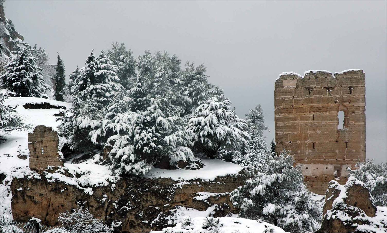
View of the North Santa Catalina Watchtower. The high hollows that can be seen in these two façades of the tower were the original entrances. Below them the holes where the beams of the platforms or scaffoldings to enter were placed can also be seen.
|
On the hill in the middle of this set of three towers is situated the north Santa Catalina watchtower. It is the smallest one in shape and height. The regularity and constructive rationality of this tower, with a height of 19 rammed-earth lifts, approximately 14,50 meters gives it a uniform modulation and layout of its constitutive elements. The principal access in this watchtower is at the height of 7,62 meter. This means that it was impossible to reach this point with a single ladder due to its weight and handling difficulties. So we have made an hypothesis how could be the access.
The south Santa Catalina watchtower is the third one, and is practically a twin tower to the north watchtower but slightly bigger, with a height of twenty rammed-earth lifts as in the Water Tower.
The south Santa Catalina watchtower is the third one, and is practically a twin tower to the north watchtower but slightly bigger, with a height of twenty rammed-earth lifts as in the Water Tower.
 |
|
Architectonic survey and façade analysis of the North Santa Catalina Watchtower.
|
The north and south Santa Catalina watchtowers have three of their face sloping, with the fourth one practically vertical, which gives them a truncated pyramid shape. These slopes were constructed by putting an upper strut smaller than the lower one. For a slope of two degrees it should be 22 millimeters smaller.

To balance these platforms, they would be counter weighted on the interior with other boards that allowed for a descent inside the tower, since the first story was not open to the outside.

With this study we wanted to uncover the underlying latent life in these fortresses, concentrated in a valley of the south-east of the Iberian Peninsula. They contribute very valuable information about the territorial organization in border areas between Christians and Muslims during the thirteenth century. The analysis of this towers built in rammed-earth has answered some questions related to their settlement, use and constructive technologies. The study has allowed us to compare and to classify them with similar examples of rammed-earth architecture in the north of Africa and other Mediterranean places.
The twin watchtowers preserved in the plains of Santa Catalina would correspond to the last typology. They have the peculiarity of their access, situated at over 7 meters from the ground. This fact shows that they probably were isolated towers and that they have not a walled enclosure. The facade analysis of the rammed-earth walls and the existing hollows and holes revel that the way of climbing to the entrance door was by means of an exterior system of platforms anchored to the tower. Other discover concern the quality of the conservative process of the towers compared to other contemporary examples. It shows an advanced use of the rammed-earth with lime crust technology. This is one of the causes for the exceptional preservations of several of these towers, placed in a mountainous landscape subjected to big changes of temperature and humidity and one of the areas of major seismicity on the Iberian Peninsula.
The archaeological remains of these towers show the proportions of the mixture and the modulation of the walls, as well as an advanced use of structural reinforcements in the weakest points of the towers. The settlement pattern of the castles with enclosure fulfilled a double defensive and productive function, controlling roads and an agricultural area between 250 and 350 hectares, being a prime reference for territorial links and determining the economic and social development of their area of influence. This organization of the territory gives information to similar criterion shown in the defensive structures of the oases between the Sahara desert and the south of the atlas mountings at least from the middle ages.
The stratigraphic and material analysis of the surface archaeological remains from the medieval fortifications of the Segura valley, when compared with other contemporary existing examples in the basin of the Mediterranean, has enabled the in-depth study of their details, particular characteristics and the constructive technology used. It has enabled to be obtained and consolidate the study process of these remains that defined a frontier in the thirteenth century and now they are building a landscape.
4th Postgraduate Conference in Conflict Archaeology
University of Oxford
6th / 8th December 2015
English version:
International Conference on Preservation, Maintenance and Rehabilitation of Historical Buildings and Structures, p 333-344. Tomar (Portugal) 2014
Versión española:
El sistema de Torres de origen medieval en el valle de Segura de la Sierra
La construcción de un paisaje. Boletín del Instituto de Estudios Giennenses, 212, 99-165. Jaén 2015.
Presentation